

Tropical cyclones: your questions answered
14 May 2020
Tropical cyclones are one of nature's fiercest phenomena, and also one of its most fascinating. The intricacies of these spiralling wind and rain systems are almost enough to make your head spin! Here our meteorologists answer some of your common questions about cyclones.
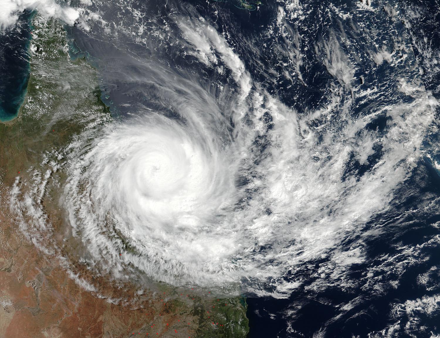
Image: Severe tropical cyclone Debbie, March 2017. Credit: NASA/NOAA
Why are warm sea surface temperatures essential for tropical cyclone development?
Moisture from the ocean is the cyclone's fuel. The moisture that evaporates from the sea surface rises into the atmosphere. As it condenses back into liquid water, it releases energy. As sea surface temperatures get warmer more energy is available. So warm sea surface temperatures are essential for developing and sustaining tropical cyclones so that they don't run out of fuel.
What's the difference between tropical cyclones, hurricanes, and typhoons?
Essentially, the only difference is where in the world the storm occurs. The terms 'hurricane' and 'typhoon' are regionally specific names for a cyclone. 'Hurricane' is used in the Northern Atlantic Ocean, central North Pacific Ocean, and the Eastern North Pacific. 'Typhoon' is used in the Northwest Pacific Ocean. In the South Pacific and Indian Oceans the term 'tropical cyclone' is used.
The tropical cyclone season in Australia is officially between 1 November and 30 April, with most cyclones occurring from January to March. Hurricanes and typhoons typically develop at different times of the year. The Atlantic hurricane season runs from 1 June to 30 November, and the Eastern Pacific hurricane season runs from 15 May to 30 November. Most typhoons form from May to October, although they can occur year-round.
Why do tropical cyclones and hurricanes rotate in different directions?
Cyclones rotate clockwise in the southern hemisphere and anticlockwise in the northern hemisphere. This is due to the Coriolis force, caused by the Earth's rotation.
Why don't we get tropical cyclones at the equator?
Cyclones need a little help to start spinning. They usually get this from the Coriolis force. However the Coriolis force is very weak near the equator and gets stronger towards the poles. So, although the oceans are warm near the equator and supply plenty of 'fuel' (see 'Why are sea surface temperatures essential for tropical cyclone development?'), there's not enough Coriolis force to 'start the motor'.
Are bigger tropical cyclones more intense?
No, cyclones of any size can be dangerous! In 1974 severe tropical cyclone Tracy devastated Darwin, taking 71 lives and destroying most of the city's buildings. Although Tracy crossed the coast as a category 4, it was a small, slow-moving system with the radius of gale force winds only 46 km.
What's the history behind tropical cyclone names?
Since the late nineteenth century, cyclones have been receiving names thanks to a colourful and memorable character of early Australian meteorology – Clement Wragge. Nicknamed 'Inclement', Wragge left the UK for Australia in 1883, and played an important part in the history of Australian meteorology. He started Queensland’s Central Weather Bureau in 1887, where he was chief meteorologist until 1902. Wragge initiated the naming of weather systems, choosing names ranging from mythological creatures to politicians who annoyed him.
Always included in the historical accounts of naming storm systems, Wragge influenced the naming of powerful weather systems worldwide – from hurricanes to cyclones. The Bureau officially adopted a policy of naming cyclones in 1963, and the first cyclones to be named were Audrey and Bessie in January 1964. Female names were used exclusively until 1979.
We maintain a list of names, arranged alphabetically and alternating between male and female. See the list here.
Video: How are tropical cyclones named?
How many tropical cyclones does Australia typically see per year?
Australia sees around 11 cyclones on average each year, with 4 crossing our coast. But it only takes one cyclone to have a devastating effect on communities.
Can tropical cyclones occur outside of the official season?
Yes. While it's unusual to have a cyclone outside of the official season (1 November to 30 April), in the Australian region cyclones have been recorded in every month of the year!
On 1 July 2015 tropical cyclone Raquel became the first cyclone on record to form in July in the Australian eastern region.
Which part of Australia is most tropical cyclone prone?
The north-west Australian coastline between Broome and Exmouth is the most cyclone-prone region of the entire Australian coastline, having the highest frequency of coastal crossings.
Why? Cyclones typically form in the deep tropics (but not too close to the equator – see above) and initially move towards the west-south-west. As they get further away from the equator, they encounter winds that cause them to re-curve and be steered first towards the south and then towards the south-east. Hence many cyclone tracks in the Australian region are shaped a little like the letter C. On the east coast of this initially leads to cyclones heading towards the coast but then often re-curving away before they affect coastal communities. On the west coast this same behaviour means cyclones usually head out into the Indian Ocean before turning back toward the coast.
How far south can tropical cyclones go?
While our tropics are most prone to the direct impact of cyclones, they or their effects can be felt as far south as Perth on the west coast, and into NSW on the east coast. The most common of these effects is heavy rain and associated flooding after a cyclone has weakened. However, some cyclones lose their tropical cloud pattern and still produce gale-force winds, heavy rain and flooding when they move outside the tropics. When this happens they're called 'sub tropical' or 'extra tropical' cyclones. Read more here.
Tropical cyclone Ned in 1989 is the furthest south a tropical cyclone has crossed the coast, crossing near Perth on the morning of 1 April before weakening to a low. However it’s worth noting that severe tropical cyclone Alby (1978) had a much more severe impact on southwest Western Australia, (including Perth), even though it didn't actually cross the coast – a reminder that the effects of tropical cyclones can be felt hundreds of kilometres from the centre.
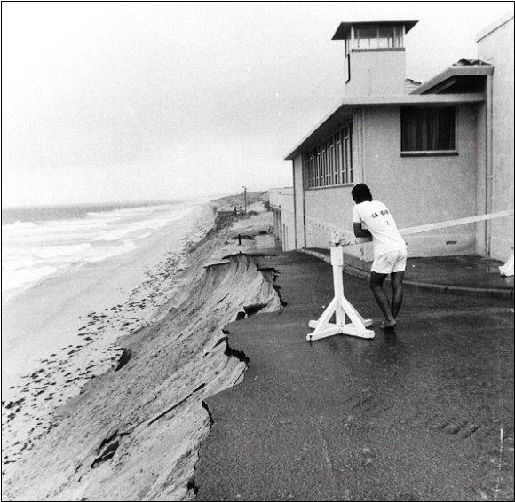
Image: Coastal erosion on Perth's beaches caused by severe tropical cyclone Alby. Photo reproduced courtesy of The West Australian.
How do you forecast the path of a tropical cyclone?
Cyclones can follow quite erratic paths, but it's remarkable how accurately we can forecast their paths. The key is understanding the flow of the winds in the surrounding environment. These winds guide the speed and direction of the overall movement of the cyclone. If the right ingredients remain then the cyclone may continue to strengthen as it moves. On the other hand, if the cyclone moves into an environment that is less favourable, such as over land or cooler waters, or into regions where the winds vary greatly with height (wind shear), it will weaken.
Forecasting cyclone movement is complicated for many reasons. Computer weather models don't always capture the situation accurately. Sometimes that's because of limitations in how well we can observe the current state of the atmosphere. Sometimes it's because small changes in the atmosphere can result in large changes to the track or intensity of the cyclone. And sometimes it's because our scientific understanding is still incomplete. However, the last few decades have seen a truly remarkable improvement in our ability to forecast cyclones, thanks to better science, much faster computers and a huge increase in satellite observations.
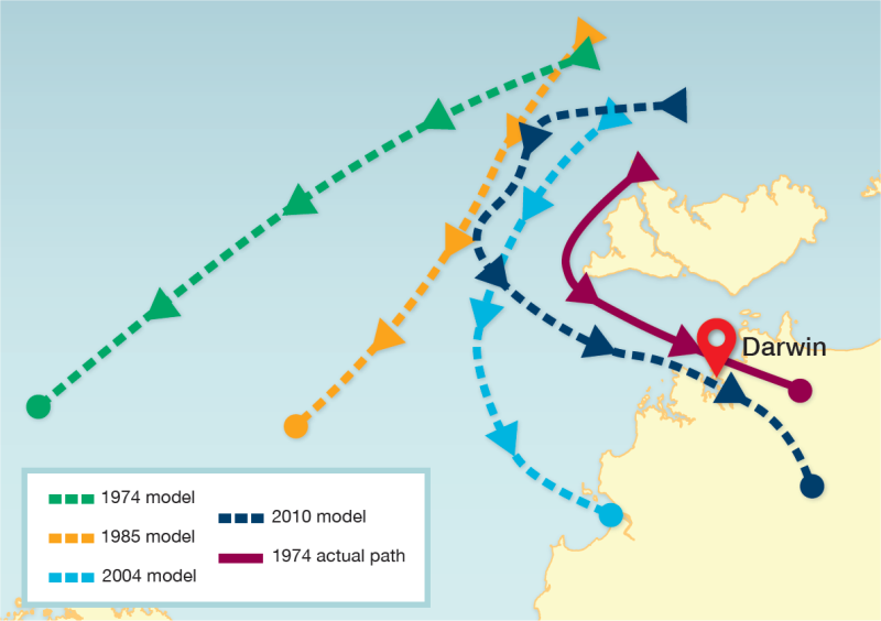
The map below shows how steadily improving weather models between 1974 and 2010 would have forecast the path of severe tropical cyclone Tracy, coming closer and closer to the path it actually took. Read more here.
Do major climate drivers influence tropical cyclones?
In the Australian region, there has historically been a significant relationship between the ENSO phase (El Niño, La Niña or neutral) and tropical cyclone frequency. During El Niño, the number of cyclones is typically below average, whereas during La Niña, numbers are typically above average. The influence of ENSO is usually stronger over the north-west of Australia than the Coral Sea.
With regard to the Indian Ocean Dipole (IOD), years with a positive IOD typically see below-average tropical cyclone numbers, while the relationship is not particularly strong in negative IOD years. The influence of the IOD is most pronounced in the early part of the tropical cyclone season, November and December.
How is climate change expected to affect tropical cyclones?
Climate models suggest that in the future there could be a shift towards fewer, but more intense, tropical cyclones with greater rainfall in areas nearer the storms than previously observed for similar systems.
More information
For more information visit our Tropical Cyclone Knowledge Centre.
For the latest tropical cyclone warnings and advice visit www.bom.gov.au/cyclone
What causes a tropical low to become a cyclone?
How do tropical cyclones get their names?
Tropical cyclones at sea: the ocean below the storm

Comment. Tell us what you think of this article.
Share. Tell others.