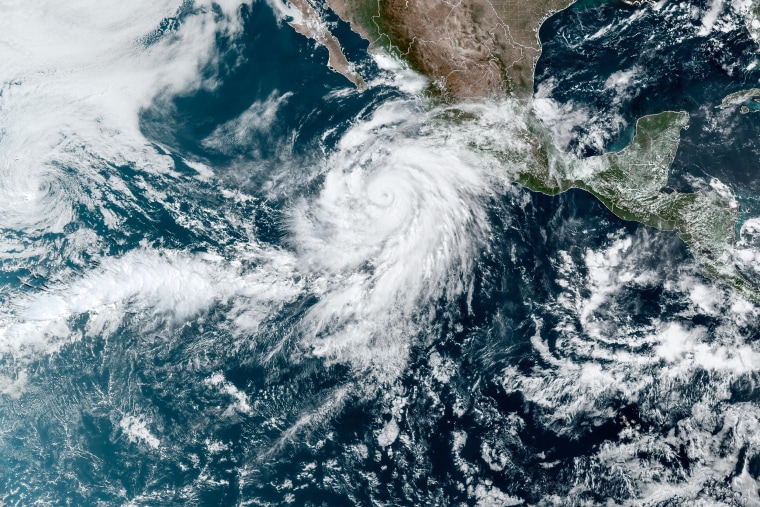
Hurricane Hilary strengthened into a Category 4 storm by Friday morning as it barreled towards the U.S. Southwest.
All eyes are on the potential for significant impacts in California and the Southwest from the storm, which had maximum sustained winds of 140 mph as of early Friday morning, according to the National Hurricane Center.
Hilary had been forecast to become a major Category 4 hurricane but it is expected to weaken, according to the center.
If it makes landfall on California as a tropical storm, it will be the first one in 84 years.
On Thursday the track had it making landfall near San Diego as a tropical storm at 6 a.m. Monday, the National Weather Service for Los Angeles said, but shifts east or west could increase impacts for LA.
The National Weather Service warned early Friday that Hilary was expected to bring "significant impacts" to the Southwestern U.S. this weekend into early next week.
California could see several months’ worth of rain in just one or two days, potentially causing flash floods.
Three to 5 inches of rain, with isolated amounts of 10 inches, could fall in parts of Southern California and Southern Nevada, the Hurricane Center said.
“The biggest threat in our area will definitely be the risk of flash flooding associated with heavy rain,” the Weather Service for San Diego tweeted Thursday night.
As Hilary heads north in the Pacific Ocean, the center of the storm will approach the Baja California peninsula over the weekend and California and the Southwest by late Sunday or early Monday.
While some wind impacts are likely for areas in the path, the rain will be the greatest risk.
Heavy rain will begin to threaten Southern California and the Southwest on Friday night and last into early next week. The peak impacts are expected Sunday and Monday, when significant flash flooding may occur. During this time, forecasters expect 2 to 4 inches of rain, with isolated amounts of more than 8 inches from Southern California to southern Nevada.
That would be a stunning amount of rain for August, the driest month of the year across the region. Los Angeles averages 0.00 inches of rain for the month and San Diego just 0.01 inches.
Ahead of the threat, the Weather Prediction Center has already placed parts of Southern California and the Southwest under a slight risk for flooding rain Saturday into Sunday and a moderate risk for heavy rain Sunday to Monday.
For the Baja California peninsula, 3 to 6 inches of rain (locally up to 10 inches) is forecast to fall through Sunday night.

The storm is forecast to weaken because of land interaction and cooler sea surface temperatures farther north, but there is still potential for it to remain a tropical storm as it approaches California.
In a summer that has already produced extreme and anomalous weather, Hurricane Hilary will add to the list. It’s unusual that the first tropical system to threaten the U.S. is on the West Coast, rather than along the East Coast or the Gulf of Mexico.
The only time a tropical storm has made landfall in California the last 100 years was in Long Beach in 1939, according to the National Weather Service.
The National Hurricane Center was also tracking two other tropical systems in the Pacific Ocean.
A weakening Tropical Storm Greg passed well south of Hawaii on Thursday morning. Except for some breezier trade winds, no major impacts to Hawaii were expected.
At 11 a.m. ET on Thursday Tropical Storm Fernanda was downgraded to a post-tropical cyclone. The remnants of Fernanda are forecast to bring some deep tropical moisture to the islands, which will increase humidity and rainfall chances for all islands. Locally heavy rain will be possible, especially across Maui and the Big Island, through Tuesday night.


