
Extremely Powerful Hurricane Katrina Leaves a Historic Mark
on the Northern Gulf Coast
A Killer Hurricane Our Country Will Never Forget
 Hurricane Katrina (August 2005) became a large and extremely powerful hurricane that caused enormous destruction and significant loss of life. It is the costliest hurricane to ever hit the United States, surpassing the record previously held by Hurricane Andrew from 1992. In addition, Katrina is one of the five deadliest hurricanes to ever strike the United States. In all, Hurricane Katrina was responsible for 1,833 fatalities and approximately $108 billion in damage (un-adjusted 2005 dollars).
On August 23rd, a tropical depression formed over the southeastern Bahamas, becoming Tropical Storm Katrina on August 24th as it moved into the central Bahamas. The storm continued to track west while gradually intensifying and made its initial landfall along the southeast Florida coast on August 25th as a Category 1 hurricane (80mph) on the Saffir-Simpson Hurricane Scale. After moving west across south Florida and into the very warm waters of the Gulf of Mexico, Katrina intensified rapidly and attained Category 5 status (with peak sustained winds of 175mph) for a period of time as it moved northwest on August 28th. Katrina weakened to a Category 3 before making landfall along the northern Gulf Coast, first in southeast Louisiana (sustained winds: 125mph) and then made landfall once more along the Mississippi Gulf Coast (sustained winds: 120mph). Katrina finally weakened below hurricane intensity late on August 29th over east central Mississippi.
The damage and loss of life inflicted by this massive hurricane in Louisiana and Mississippi was staggering with significant effects extending into Alabama and the western Florida panhandle. This was a storm that captivated the public and media with most coverage occurring in the New Orleans area. Considering the scope of its impacts, Katrina was one of the most devastating natural disasters in United States history.
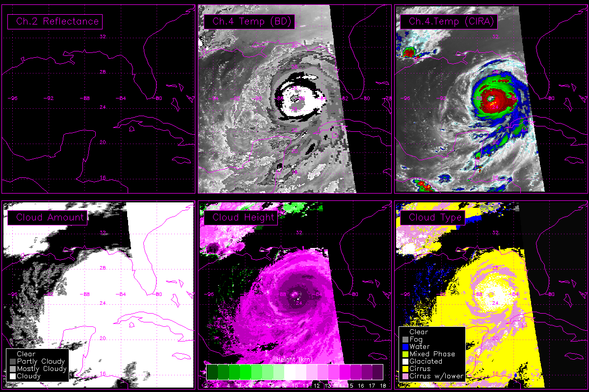
As Katrina set new minimum central pressure records while
approaching the northern Gulf Coast on Sunday, August 28th, the storm made its final turn to the north as it moved toward southeastern Louisiana. Katrina was a large storm with a very distinct eye. Early on the 28th, Katrina reached a minimum central pressure of 902mb (at the peak) - ranking 7th lowest on record for all Atlantic Basin hurricanes - and rapidly intensified to a Category 5 (175mph).
Katrina then weakened to a Category 4 hurricane as it moved across the north central Gulf and weakened further to a strong Category 3 hurricane shortly before making landfall in southeast Louisiana. The central pressure at landfall was 920mb - ranking 3rd lowest on record for a US landfalling hurricane, behind Hurricane Camille in 1969 (900mb) and the Labor Day Hurricane that struck the Florida Keys in 1935 (892mb).
The storm continued moving north-northeast and made a second landfall over Hancock County, Mississippi (near the mouth of the Pearl River) - still Category 3. After Katrina moved inland into southern Mississippi on the afternoon of August 29th, the storm left a wake of devastation that will never be forgotten. The loss of life and property damage was heightened by breaks in the levees that separate New Orleans from Lake Pontchartrain. At least 80% of New Orleans was under flood waters on August 31st.
Photo courtesy of NOAA, Office for Coastal Management, DigitalCoast
Although much will be written on the effects associated with this storm, this document will remain focused on Hurricane Katrina's impacts over inland southeast Mississippi, southwest Alabama and the northwest Florida Panhandle. Below are some of the regional impacts...
Jump to - Storm Surge, Wind, Tornadoes, Rainfall, Animations, Imagery, or Additional Information sections.
STORM SURGE
Known for its storm surge, Katrina’s highest surge was found in a zone from just east of the eye near Bay St. Louis, MS east to the northern reaches of Mobile Bay. The Mobile State Docks measured the highest storm surge of 11.45 feet, while the lowest was 4.1 feet in the Santa Rosa Sound in northwest Florida. Storm surge was as high as 12-14 feet in Bayou La Batre, AL and likely close to 20 feet along the Mississippi-Alabama border.
Many homes were engulfed by Katrina’s surge in Bayou La Batre, AL.Major beach erosion occurred from Dauphin Island to east of Destin. The west end of Dauphin Island was completely under water with most of the homes on the west end washed away. The surge in Mobile Bay led to inundation of downtown Mobile causing the imposition of a dusk-to-dawn curfew. The Wallace Tunnel was closed due to high water from the surge. Most of the businesses on the Causeway over Mobile Bay were damaged or destroyed by the high water. An oil rig broke free and floated up Mobile Bay and became lodged underneath the Cochran-Africatown Bridge. The Mobile State Docks surge value of 11.45 feet was very close to being the highest value ever recorded. The previous record of 11.60 feet was set on July 5, 1916. [The exact location and degree of accuracy of the 1916 record surge value is unknown.]
No lives were lost due to the storm surge across Mobile and Baldwin Counties in southern Alabama. Long lead warning times were given by the NWS Offices in Mobile, AL and New Orleans, LA as to how high the surge would be. As early as two days before landfall, the NWS Office in Mobile issued a Hurricane Local Statement (at 725pm) that foretold of the historic storm surge values of 8-12 feet well east of Katrina's center.
Storm Surge Map depicting a portion of storm surge data.
Observed storm surge data [Note: Highest tides occurred August 29, 2005]
Mobile State Docks (MBRA1) USS Alabama (estimated) Dauphin Island (DAUA1) Dauphin Island (DPIA1) Perdido Pass (PPSA1) Pensacola (PENF1) Destin (EPSF1) Santa Rosa Sound (FWLF1)
Katrina’s maximum windspeeds at landfall near Grand Isle, LA may have been as high as 140mph. As Katrina moved further north and made a second landfall along the Mississippi/Louisiana border, the NWS Doppler Radar in Mobile (KMOB) measured winds up to 132mph between 3,000-4,000 feet above ground level in the morning. It is estimated that 80-90% (approximately 104-119mph) of the maximum wind speed value actually reached the ground.
Tree damage across Stone and George Counties in south Mississippi was very similar to the damage produced by Hurricane Ivan (2004) across Atmore and Brewton in south central Alabama.
In this velocity loop (759-859am CDT), the eye of the storm, denoted by the large white circle, is southwest of the region of maximum surface wind speeds. These measurements are the winds flowing toward KMOB radar. [Color scale where the next highest velocity values begin: gray = 104mph; brown = 109mph; dark blue = 114mph; cyan = 117mph; green >127 mph]
The wind gust analysis map shown below is courtesy of the NWS Office in Jackson, MS.
Sustained Winds and Maximum Wind Gusts [Note: wind data occurred August 29, 2005]
Mobile Regional Airport (KMOB) Brookley Field (KBFM) Destin (KDTS) Pensacola Airport (KPNS) Crestview (KCEW) Evergreen (KGZH) Eglin AFB (KVPS) Mary Esther (KHRT) Pensacola Naval Air Station (KNPA) Eglin AFB Dauphin Island (DPIA1) Pensacola (WEAR-TV) Mobile Bay (USS Alabama) Holley Middle School, FL Destin Middle School, FL Wright Elementary School, FL Semmes
TORNADOESThe outer bands of Hurricane Katrina produced numerous tornadoes throughout the southeastern US on August 28-29, especially across southern Alabama and the northwest Florida panhandle. In total, four tornadoes rated F0 occurred in southern Alabama (2- Mobile County, 1- Baldwin County, 1- Escambia County) and five tornadoes rated F0 occurred in the northwest Florida panhandle (2- Okaloosa County, 2- Santa Rosa County, 1- Escambia County).
A majority of the tornadoes in the outerbands of Katrina were brief and on the ground for 1/2 mile to two miles. The largest tornado path occurred in Santa Rosa County near Munson, FL and was on the ground for three miles. Further inland across areas covered by the NWS Offices in Jackson, MS and Birmingham, AL, tornadoes were rated F1-F2 with slightly longer paths.
Most of the damage associated with these weak outer band tornadoes was tree and power line damage. No fatalities or injuries occurred with these tornadoes.
NOTE: The F scale was used to rate these tornadoes back in 2005. As of 2007, the NWS now uses the EF scale to rate tornadoes.
Radar animation via NCEI (formerly NCDC)
RAINFALL
KMOB radar showed the greatest rainfall amounts occurred east of Katrina’s eye and very close to the coast. A general 5-10 inches of rain fell with isolated amounts exceeding 12 inches. Rain bands extending well east of Katrina’s eye brought isolated rainfall totals of 3-6 inches over extreme northwest Florida. Significantly lighter rainfall amounts (less than 2 inches) fell east of a line from Camden, AL to Evergreen, AL to Navarre, FL. The highest rainfall total observed in our county warning area was in Philpot, FL where 7.80 inches of rain fell in 48 hours. Flash flooding occurred throughout the day as Katrina made landfall due to the heavy rainfall.
The extend of rainfall can be seen in the map of observed precipitation for the southeastern US during Hurricane Katrina's lifetime (August 24-30). Photo courtesy of NCEI (formerly NCDC).
48 hour total rainfall (inches) ending at 1159pm on August 29, 2005
Mobile Regional Airport (KMOB) Thomasville Semmes Pensacola (WEAR-TV) Daphne Philpot, FL Milton Molino
Animations
Animated Radar Imagery
Animated Satellite Imagery
Colorized IR Satellite Loop
Regional Satellite Loop
HURSAT-AVHRR Satellite Imagery
Imagery
High Water Mark Collection for Alabama
NOAA Coastal Aerial Photos
Pre- and Post-Katrina 3D Topography: Dauphin Island, AL
Before and After Photos: Dauphin Island, AL
USGS Post-Storm Photos (zoom in for details)
NOAA Hurricane Hunter Imagery INSIDE Katrina
NOAA Photo Library of Katrina
LOCAL Damage Photos:
Coden / Bayou La Batre
Dauphin Island
Downtown Mobile
Fairhope / Point Clear
Dog River
Stone/George County, MS
Northwest Florida panhandle
More Information (Technical Papers and Assessments)
NWS Service Assessment everything you want or need to know!
NCDC Technical Report
NHC Advisory Archive
NWS Post-Tropical Cyclone Reports - Katrina
NWS Mobile, AL
NWS New Orleans, LA
NCDC Special Report - Katrina
NHC Tropical Cyclone Report - Katrina
NOAA Tide Gage (Preliminary) Water Levels Report
NWS Katrina Local Write-Ups and Webpages:
NWS New Orleans
NWS Jackson
NWS Birmingham
NWS Huntsville
NWS Memphis
NWS Shreveport
NWS Nashville
Acknowledgments: Page created by Jeffrey Medlin (MIC), Ray Ball (ITO), and Gary Beeler (former WCM). Updated by Morgan Barry (forecaster), Jason Beaman (WCM), and Don Shepherd (senior forecaster, Tropical Focal Point).
LAST UPDATED: September 2022


 Follow us on YouTube