Hurricane Lee path: Storm to turn north, bring rip currents, dangerous surf to South Florida
MIAMI -- Hurricane Lee barreled over open waters Monday just northeast of the Caribbean, unleashing heavy swell on several islands as it regained some strength and expanded in size.
The Category 3 storm, packing maximum sustained winds of 120 miles per hour, is not forecast to make landfall and is expected to stay over open waters through Friday.
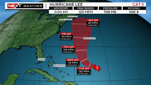
As of 11 a.m. Monday, the system was moving northwest at 8 miles per hour, according to the National Hurricane Center.
Lee is forecast to strengthen into a Category 4 sometime Tuesday but stay to our east in the Atlantic Ocean.
The storm is expected to weaken but still be a major Category 3 Hurricane by Wednesday.
By Thursday it will weaken to a Category 2 and by Friday a Category 1.
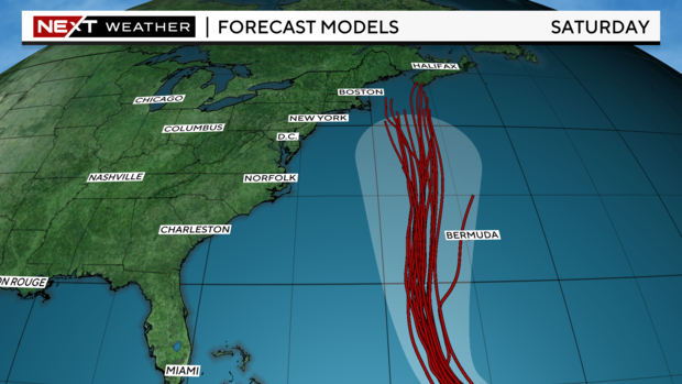
While Lee will remain well to the East of South Florida, dangerous surf, rip currents and hazardous boating conditions are likely midweek.
Residents who live along the New England coast to Nova Scotia will need to keep an eye on Lee for possible impacts.
Last week, Lee strengthened from a Category 1 storm to a Category 5 storm in just one day.
"We had the perfection conditions for a hurricane: warm waters and hardly any wind shear," said Lee Ingles, a forecaster with the National Weather Service in San Juan.
By Saturday night, it had slowed to a Category 2 hurricane, but began restrengthening Sunday. Lee is expected to strengthen further in upcoming days and then weaken again, the U.S. the National Hurricane Center said.
The center Lee also was growing in size, with hurricane-force winds extending outward up to 75 miles from the center and tropical storm-force winds extending outward up to 175 miles.
Breaking waves of up to 20 feet were forecast for Puerto Rico and nearby islands starting early this week, with authorities warning people to stay out of the water. Coastal flooding also was expected for some areas along Puerto Rico's north coast and the eastern portion of St. Croix in the U.S. Virgin Islands, according to the National Weather Service in San Juan.
Lee was forecast to take a turn to the north by Wednesday. However, its path after that remained unclear.
"Regardless, dangerous surf and rip currents are expected along most of the U.S. East Coast this week as Lee grows in size," the center said.
Lee is the 12th named storm of the Atlantic hurricane season, which runs from June 1 to Nov. 30 and peaked on Sunday.
Tropical Storm Margot became the 13th named storm after forming Thursday evening, but it was far out in the Atlantic and posed no threat to land. It was about 1,185 miles (1,910 kilometers) west-northwest of the Cape Verde Islands late Sunday. Its winds stood at 65 mph (100 kph) and it was forecast to strengthen into a hurricane by Monday night. It was moving northward at 8 mph (13 kph).
The National Ocean and Atmospheric Administration in August forecast between 14 and 21 named storms this season. Six to 11 of them are expected to become hurricanes, and of those, two to five might develop into major hurricanes.
In the Pacific, Jova weakened to a remnant low as it whirled over open waters far from Mexico's southwest coast and posed no threat to land.
The Associated Press contributed to this report.