Tropical Storm Idalia on path to Florida's Gulf Coast; expected to become hurricane 'at any time': NHC
FOX 35 is no longer updating this story. Click here for live updates on Hurricane Idalia.
Tracking Idalia: Stream FOX 35 News
ORLANDO, Fla. - Tropical Storm Idalia is forecast to become a dangerous major Category 3 hurricane on its path to Florida this week, according to the National Hurricane Center.
IMPORTANT LINKS
- List: School Closures
- FOX 35 Orlando Hurricane Center: Maps, models, latest track for Tropical Storm Idalia
- Shelter information
- Download FOX 35 News, FOX 35 Storm Team apps
Live updates
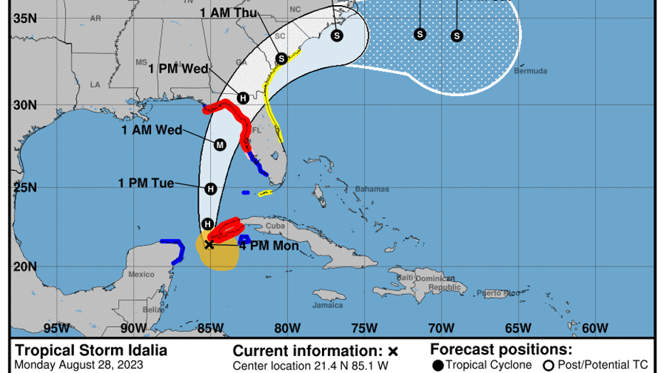
11 PM Advisory | Idalia maintained its status as a tropical storm late Monday with maximum sustained winds at 70 mph and movement to the north at 8 mph. The center of Tropical Storm Idalia was located 230 miles southwest of The Dry Tortugas and just 10 miles northwest of the western tip of Cuba.
Idalia could become hurricane at any time
Idalia maintained its status as a tropical storm late Monday with maximum sustained winds at 70 mph and movement to the north at 8 mph. Rapid strengthening is predicted during the next day or so. Idalia could become a hurricane at any time and is forecast to become a major hurricane by late Tuesday or Tuesday night.
Rapid strengthening is predicted during the next day or so. Idalia could become a hurricane at any time and is forecast to become a major hurricane by late Tuesday or Tuesday night. Tropical-storm-force winds extend outward up to 150 miles from the center.
The combination of a dangerous storm surge and the tide will cause normally dry areas near the coast to be flooded by rising waters moving inland from the shoreline. The water could reach heights of 12 feet above ground along of parts of Florida's Nature Coast.
8 PM Advisory | Idalia remained a tropical storm early Monday evening with maximum sustained winds unchanged from the previous advisory at 70 mph. The center of Tropical Storm Idalia was located 20 miles south-southwest of western Cuba and 250 miles south-southwest of The Dry Tortugas off Florida.
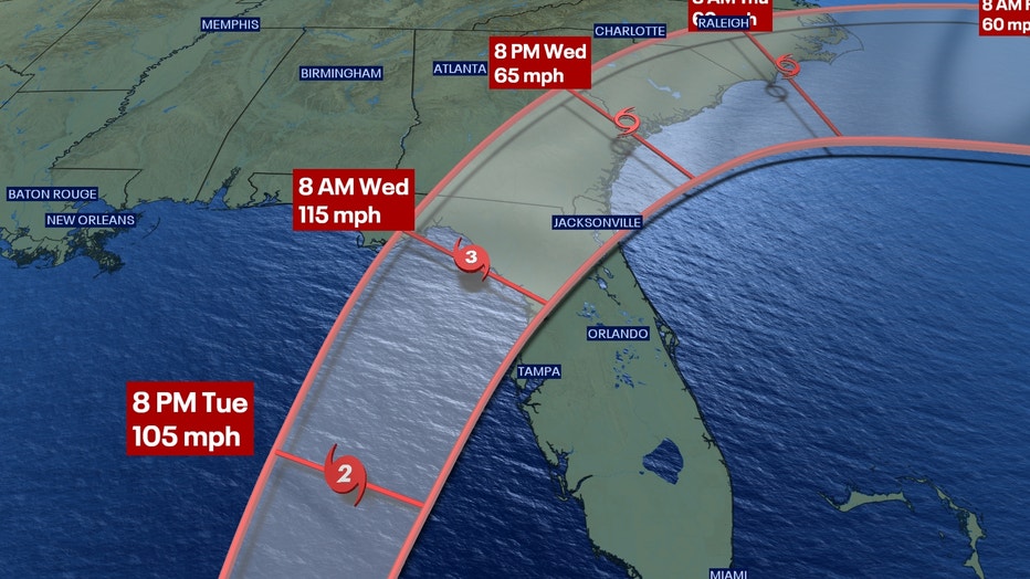
Idalia is expected to track to the north overnight and then to the north-northeast on Tuesday and Wednesday as it picks up speed. The storm was moving at 8 mph as it approached the warmer waters of the Gulf of Mexico. On the forecast track, the center of Idalia is expected to pass near or over western Cuba, then over the eastern Gulf of Mexico on Tuesday, and reach Florida's Nature Coast on Wednesday as a hurricane.
7:20 PM | Tolls suspended: To help speed evacuations ahead of what is expected to be a powerful Hurricane Idalia, the state is lifting tolls at 4 a.m. Tuesday in parts of the state. Gov. Ron DeSantis said Monday he’s directed the Department of Transportation to stop collecting tolls in Citrus, Hernando, Hillsborough, Lake, Pasco, Pinellas, and Sumter counties. "You don't need to leave the state. You don't need to drive 100 miles to ride out the storm," DeSantis said during a news conference at the state Emergency Operations Center. "If you're in those low-lying areas, the reason why they (local officials) are advising you to evacuate is because you're going to be susceptible to storm surge."
6:50 PM | Flagler County Schools has canceled classes on Wednesday, Aug. 30, in anticipation of Idalia. Full school closures list.
5:45 PM | Busch Gardens Tampa Bay: Due to the projected path of Tropical Storm Idalia, Busch Gardens Tampa Bay has enacted its Named Storm Policy and will close at 3 p.m. Tuesday August 29 and remain closed Wednesday, August 30. The park plans to reopen on Thursday, August 31.
5:30 PM | North Central Florida is preparing for Idalia, which is expected to become a major hurricane by the time it makes landfall along the Nature Coast. Residents in Cedar Key are preparing for the storm and the University of Florida announced that it will be closing the campus on Tuesday at noon.
North Central Florida keeps eye on Idalia
North Central Florida is preparing for Idalia, which is expected to become a major hurricane by the time it makes landfall along the Nature Coast. Residents in Cedar Key are sealing up homes and businesses while students at the University of Florida in Gainesville are contemplating evacuating the campus before the storm's arrival
5 PM Advisory | Tropical Storm Idalia remains a tropical storm, but is nearing hurricane strength, the National Hurricane Center said.
It's 35 miles south-southwest of western Cuba and 265 miles south-southwest of The Dry Tortugas off Florida. It has maximum sustained winds of 70 mph and is traveling north at 8 mph.
"A northward motion is expected through tonight, followed by a faster north-northeast motion on Tuesday and Wednesday. On the forecast track, the center of Idalia is forecast to pass near or over western Cuba tonight, over the eastern Gulf of Mexico on Tuesday, and reach the Gulf coast of Florida within the Hurricane Warning area on Wednesday."
"Maximum sustained winds are near 70 mph (110 km/h) with higher gusts. Rapid strengthening is predicted during the next day or so. Idalia is forecast to become a hurricane this evening or tonight, and become a major hurricane by late Tuesday or Tuesday night. "
4:34 PM | Central Florida Zoo & Botanical Garden will close at noon on Tuesday, Aug. 29, 2023 ahead of Tropical Storm Idalia, which is forecast to become a hurricane before it makes landfall. The Zoo will stay closed through Wednesday, Aug. 30. It is planning to reopen on Thursday, Aug. 31.
"The Zoo’s main priority is the safety of its animals, staff and patrons. The Zoo is following its animal protocols for hurricanes, and staff members are closely monitoring the storm. Zoo leaders will announce any further changes to operations as they continue to receive updates and assess the situation."
4:05 PM | LYNX, which operates buses in Orange, Osceola, and Seminole counties, said it is monitoring potential impacts from Tropical Storm Idalia, but is operating on its normal schedules. If sustained winds reach 35 mph, buses will stop.
3:30 PM | SunRail Service Suspension: The Florida Department of Transportation said it will suspend SunRail service on Tuesday, August 29, 2023, in anticipation of Idalia's arrival. Following the conclusion of Monday's regular service hours, FDOT crews will begin securing railroad gates at 126 railroad crossings on the nearly 62-mile railway corridor, including the removal of longer railroad gates. The SunRail fleet will also be secure until the storm passes and conditions stabilize.
FDOT said it will resume service once an inspection of the entire railway corridor is completed. Restoration of service includes reinstalling gates, removal of any obstruction on the railroad tracks, and conducting safety inspections.
2 PM. advisory | Tropical Storm Idalia is strengthening as it nears the western tip of Cuba, according to the National Hurricane Center. Forecasters say there is a danger of life-threatening storm surge inundation along parts of Florida's Gulf Coast, including Tampa Bay and Florida's Big Bend.
Hurricane conditions are expected along parts of the Florida Gulf Coast – potentially bringing destructive winds where the core of the storm moves onshore.
Areas of flash and urban flooding are expected across parts of Florida's west coast, the Florida Panhandle, and southern Georgia Tuesday into Wednesday, spreading into portions of the eastern Carolinas Wednesday into Thursday.
11 AM advisory | Tropical Storm Idalia is expected to become a hurricane on Monday on its way to Florida, where it could make landfall earlier this week as a "dangerous major hurricane," the National Hurricane Center said.
Storm surge and hurricane warnings have been issued for Florida's west coast. Life-threatening storm surge and dangerous winds are becoming "increasingly likely" for parts of Florida.
Tropical Storm Idalia is located about 80 miles south-southwest of Cuba and 305 miles south-southwest of the Dry Tortugas. It has maximum sustained winds of 65 mph. It is moving north at 8 mph.