Hurricanes Are Too Fast for Category 5
Climate change could double the risk of hurricanes with wind speeds greater than 192 miles an hour in the Gulf of Mexico.

Listen to this article
Produced by ElevenLabs and News Over Audio (NOA) using AI narration.
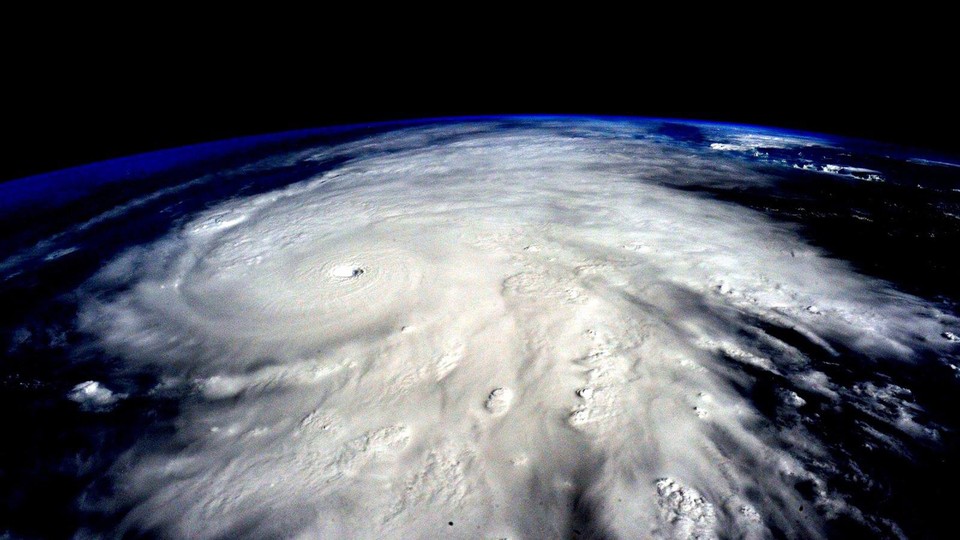
At 149 miles an hour, the world’s fastest roller coaster, Formula Rossa in Abu Dhabi, is so quick that riders must don goggles to protect their eyes from the wind. But even the formidable Formula Rossa is no match for the 157-mile-an-hour-plus winds of a Category 5 hurricane, which can collapse a home’s walls and cave in its roof. And yet, according to a new paper, Category 5 may itself be no match for several recent hurricanes.
Right now, every hurricane with maximum sustained wind speeds above 156 miles an hour is considered a Category 5 on the Saffir-Simpson Hurricane Wind Scale—whether it’s blowing 160 mph, like Hurricane Ian, or roughly 215 mph, like Hurricane Patricia, which struck Mexico in 2015. To distinguish between extreme storms and, well, extremely extreme storms, James Kossin, a distinguished science adviser at the climate nonprofit First Street Foundation, and Michael Wehner, a senior scientist studying extreme weather events at Lawrence Berkeley National Laboratory, explored adding a hypothetical sixth step to the scale. Category 6 hurricanes, they write, would encompass winds above 192 miles an hour. By their definition, five hurricanes—all of which occurred in about the previous decade—would have been classified as Category 6.
When Kossin and Wehner ran climate models into the future, they found that if global temperatures rise 2 degrees Celsius, the risk of Category 6 storms would double in the Gulf of Mexico and increase by 50 percent near the Philippines. “Adding a category better describes these rather unprecedented storms,” Wehner told me. Actually changing the Saffir-Simpson scale would require research into how a revised system would communicate disaster risk, the authors noted in the paper; still, “we really should consider the idea of scrapping the whole thing,” Kossin told me. And he’s not the only one who thinks so. “I’m not sure that it was ever a really good scale,” Kerry Emanuel, a leading atmospheric scientist at MIT and the editor of the paper, told me. “I think that maybe it was a mistake from the beginning.”
The Saffir-Simpson Hurricane Scale hit the meteorological scene in the 1970s, when a civil engineer (Herbert Saffir) and the head of the National Hurricane Center (Robert Simpson), teamed up to design a simple one-through-five rating for a hurricane’s potential to cause damage by relating wind speed, central pressure, and potential storm-surge heights. For a few decades, things went smoothly. But by the mid aughts, it was clear that the scale’s categories didn’t always reflect the damage on the ground. Hurricane Charley, in 2004, weighed in at Category 4, but caused relatively little destruction. Hurricane Ike, by contrast, made landfall near Galveston, Texas in 2008 at only Category 2, but killed 21 people directly and caused an estimated $29.5 billion in damages across Texas, Louisiana, and Arkansas.
The difference was water. Charley, despite its high winds, was a relatively dry storm; Ike caused a 20-foot storm surge. Sandy wasn’t even a hurricane when it flooded 51 square miles of New York City, casting the ocean into the streets, overtopping boardwalks and bulkheads. About 90 percent of hurricane deaths in the U.S. come from storm surge and inland flooding, Jamie Rhome, the deputy director of the NHC, told me in a statement. In 2010, the NHC tweaked the scale’s name to the Saffir-Simpson Hurricane Wind Scale, removing storm surge and central pressure to clarify that it couldn’t measure a hurricane’s overall potential destruction.
But Saffir-Simpson is deeply embedded in the public psyche. Like the Richter scale’s nine or the DEFCON system’s one, people tend to think of Saffir-Simpson’s five as a definitive ranking of danger. “The simplicity of the scale is both a flaw and an advantage,” Brian McNoldy, an atmospheric scientist at the University of Miami’s Rosenstiel School of Marine, Atmospheric & Earth Science, told me. Category 5 is visceral in a way that inches of rain and projected feet of storm surge perhaps are not. But Saffir-Simpson is so misunderstood that during presentations, McNoldy likes to tell people: “There’s more to the story than the category.”
The NHC, which forecasts and communicates hurricane risk to the public, has tried to expand the public’s focus from the particular Saffir-Simpson designation. Instead, the center has emphasized hurricanes’ many additional hazards, such as rainfall, tornadoes, and rip currents. Rebecca Morss, who founded the Weather Risks and Decisions in Society program at the National Science Foundation’s National Center for Atmospheric Research, told me that adding a Category 6 could turn the focus away from those many other dangers.
For its part, the NHC seems unenthusiastic about adding a Category 6. “Category 5 on the Saffir-Simpson scale already captures ‘catastrophic damage’ from wind, so it’s not clear there would be a need for another category even if storms were to get stronger,” Rhome, the NHC deputy, said. A sixth category wouldn’t necessarily change FEMA’s preparations before a storm makes landfall, either, because the agency anticipates that any Category 4 or 5 storms will have significant impacts, a spokesperson for the agency wrote in an email, stressing that emergency managers should consider overall risks from a hurricane’s hazards.
Atmospheric scientists and meteorologists have tried to create better systems, based on surface pressure to better predict storm surge, or integrated kinetic energy to better estimate storm size. But even with a system that incorporates wind speed, storm surge, rain, and other factors—eventually, “you’ll encounter a storm that breaks the rules,” Emanuel told me. An ideal hurricane alert, Morss said, would tell people about the risks they may face in their specific location and how they can protect themselves. It would also point them toward reliable sources of accurate, timely information as the storm approaches. “It’s difficult to do that with a single hurricane-risk rating,” she told me.
Emanuel and others believe that the United States could stand to learn from the United Kingdom’s system, which categorizes severe weather as either yellow, amber, or red—where red means citizens are in imminent danger. That color alert is accompanied by a “crisp narrative,” he said, summarizing what people can expect to see—for instance, a few feet of flooding, a storm surge, heavy rain, high winds. This kind of people-centered hurricane system would require input not just from scientists but also from communications experts, sociologists, psychologists, and people who have lived through hurricanes. Creating a system with that degree of nuance would take a while, and in the meantime, Saffir-Simpson is the best we’ve got. “We want to stick with what people know until we have something better,” Kim Wood, an atmospheric scientist at the University of Arizona, told me.
Long before there was Saffir-Simpson, there was Simpson, a 6-year-old watching the water rise outside his family’s home in Corpus Christi, Texas. His father hoisted him on his back and they swam three blocks to safety in the town courthouse. But even Simpson couldn’t have imagined the kind of storms we face today, Emanuel said. In fact, it’s remarkable that he and Saffir gave us a succinct way to describe something as complex as potential hurricane damage. Kossin told me he has nothing but admiration for the work of Saffir and Simpson, whom he met back in the 1990s. But today, armed with more decades of data, maybe we can build something even better.