| Above: Aerial view taken three days after the 1935 hurricane of the ill-fated rescue train sent into the Florida Keys to rescue veterans working on a railway. High winds and an estimated 18-foot storm surge swept the train off the tracks. The hurricane killed at least 257 veterans and 228 civilians. Image credit: State Library and Archives of Florida. |
Hurricane Dorian jumped to Category 4 strength on Friday night, with top sustained winds at 130 mph as of a special 8:30 pm EDT advisory from the National Hurricane Center and even stronger—140 mph—as of 11 pm EDT. The northwest Bahamas, where Dorian may strike on Sunday, were under a hurricane warning (excluding Andros Island, where a hurricane watch was in effect).
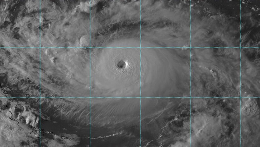
Hurricane hunters found that Dorian's minimum central pressure had plummeted to 947 millibars—a drop of more than 20 millibars in just a few hours—and satellite imagery showed that Dorian was becoming a formidable hurricane. Upper-level analysis showed dual outflow jets, one to the west and one one to the northeast, which were ventilating the storm, giving it a dramatic east-west elongation, and allowing rapid intensification to occur.
 |
| Figure 1. A visible-wavelength high-resolution satellite image shows the sharply defined eye of Hurricane Dorian at around 2200Z (6 pm EDT) Friday, August 30, 2019. Image credit: tropicaltidbits.com. |
Forecast models on Friday were trending toward a pronounced slowdown as Dorian approaches Florida's central coast late Monday and early Tuesday. This may result in the storm making a sharp northward turn on Tuesday, which could occur just inland, on the coast, or just offshore. Such a turn near the coast—as predicted by most members of the 12Z Friday GFS and European model ensemble runs—could push hurricane impacts well north of the landfall point. The risk that Dorian will cross Florida and move into the Gulf of Mexico is dropping.
We are watching the model trends and Dorian's evolution closely and will have our next full update by midday Saturday. Please see our Friday morning post and weather.com's continuing coverage for more details on Dorian.
Tropical troubles on Labor Day weekend: 1935 and 2019
With an intensifying Hurricane Dorian bearing down towards Florida over Labor Day weekend, it’s worth comparing Dorian to another famous Labor Day weekend hurricane: the great Florida Keys Labor Day Hurricane of 1935, the most intense landfalling hurricane in U.S. history. It is unlikely, but theoretically possible, that Dorian could grow as strong as the 1935 hurricane over the next several days. Dorian will also likely be a much larger and longer-lived storm than the 1935 hurricane at landfall, which will raise the odds of widespread coastal surge. Given the current track forecasts for Dorian, though, the storm is highly unlikely to make landfall at the 1935 storm’s record-breaking landfall intensity: 185 mph winds and a pressure of 892 mb.
 |
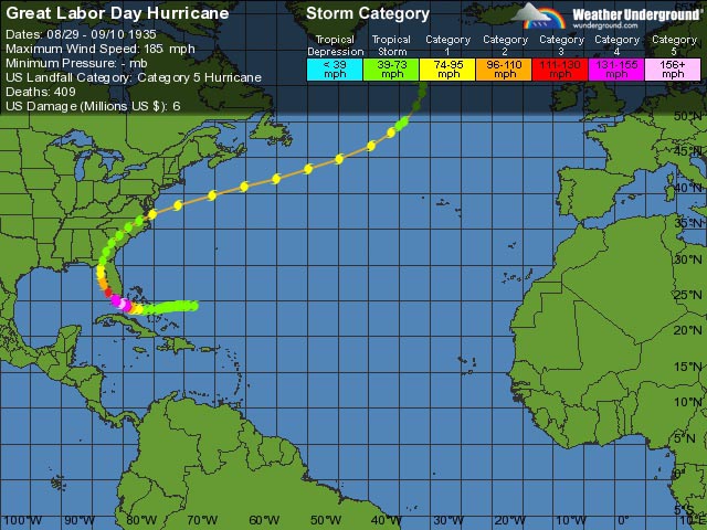
| Figure 1. Track of the 1935 Labor Day Hurricane. |
History of the 1935 hurricane
The Labor Day hurricane of 1935 developed very rapidly from a system that was classified as a tropical storm less than two days before landfall in the Keys. Brushing the south end of Andros Island in The Bahamas, the storm headed toward the north coast of Cuba before angling unexpectedly rightward and intensifying with astonishing speed as it approached the Keys. In just 42 hours, the 1935 hurricane intensified from a tropical storm with 70 mph winds to an incredibly intense Category 5 beast with 185 mph winds as it passed over the very warm waters of the Florida Straits.
The great Labor Day Hurricane of 1935 made landfall in the upper Florida Keys during the late evening hours of Monday, September 2, 1935—Labor Day. It was originally classified as having 160 mph winds at landfall, but a reanalysis done in 2014 concluded that the mighty storm made landfall with 185 mph winds and a central pressure of 892 mb--all-time landfall records for the Western Hemisphere. Local weather observer Ivar Olsen measured 26.35” (892 mb) in the eye with a barometer that was later tested and proven reliable at the Weather Bureau. This remains the lowest value ever measured by a ground-based station in a tropical cyclone in the Western Hemisphere.
 |
| Figure 2. The maximum potential intensity (MPI) for Hurricane Dorian for August 30, 2019 (shown in colors above; the green lines show sea surface temperature in degrees C). MPI is computed using thermodynamic theory, based on the prevailing temperatures in the atmosphere and ocean. Dorian was over a region on Friday where the MPI was 135 - 150 knots (155 - 170 mph, medium blue colors), and is projected to move into a region on Sunday and Monday (darker blue colors) where the MPI is a Category 5 storm with winds of 150 – 175 knots (170 – 200 mph). The corresponding central pressure is 890 - 900 mb (image not shown here). Image credit: wxmap.org. |
Theory says Dorian could match the 1935 hurricane
Using thermodynamic theory, we can compute a quantity called the maximum potential intensity of a tropical cyclone, based on the prevailing temperatures in the atmosphere and ocean. The maximum potential intensity (MPI) of a hurricane reaching the northwest Bahamas as computed on Friday, August 30, 2019 was for winds of 170 – 200 mph and a central pressure of 890 – 900 mb. The MPI changes only slowly over a period of days, so it is safe to assume that Dorian’s MPI will be similar to that on Monday, when it is over the northwest Bahamas.
A great book on the 1935 hurricane was just published
The most heartbreaking parts of the saga are vividly told in “Storm of the Century: The Labor Day Hurricane of 1935” by Wille Drye. The revised version of book he originally wrote in 2002 was published this summer. The book is an encylopedia of detail on the storm, following multiple engrossing stories. Most prominent is the story of the hundreds of veterans had been deployed to the Keys to build the most difficult sections of the highway that now runs the length of the island chain, from Key West to Miami.
Many veterans of World War I had struggled to find work and deal with postwar life, and the Great Depression hit them particularly hard. At the Keys, they were housed in hastily built barracks and tents that stood no chance of surviving a Category 5 hurricane. Superiors recognized the potential for disaster if a hurricane were to strike, but as “Storm of the Century” recounts in agonizing detail, a series of miscues--ranging from slack holiday schedules to telephone miscommunications to obstructions along the railway track to simple inertia--meant that a rescue train ran hours later than it should have. The train ended up pushed off its tracks by the storm; miraculously, everyone on board survived, but the train had not yet reached hundreds of the most vulnerable workers. At least 257 veterans and 228 civilians died in the winds and storm surge of that horrifying evening. (See video at bottom, which includes recent interviews with two survivors.)
I wrote a jacket blurb for the book, which reads: Willie Drye’s excellent and remarkably detailed book brings the reader directly into the eye of the storm, where he follows a host of dramatic stories for survival. The story and lessons of the 1935 hurricane are important to learn, since a warming climate promises to make such maximum-strength hurricanes more common at a time when coastal population is surging and sea level is rising.
Below: This Miami Herald video includes compelling photos from the Labor Day hurricane of 1935, as well as recent interviews with Everett Albury and Alma Pinder Dalton, who were 6 and 11 when the hurricane struck. Video credit: Jenny Staletovich/Miami Herald staff. Thanks to wunderground member barbamz for locating this video.
Bob Henson co-wrote this post.


