| Above: Hurricane Gert as seen by the GOES-16 satellite at 10:45 am EDT August 16, 2017. At the time, Gert was a Category 1 storm with 90 mph winds. Image credit: NOAA/CIRA/RAMMB. NOAA’s GOES-16 satellite has not been declared operational and its data are preliminary and undergoing testing. |
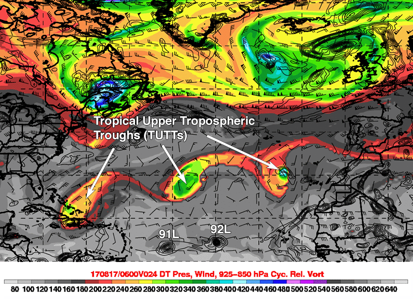
We’ve entered the last half of August, when the busiest portion of the Atlantic hurricane season begins. Befitting this time of year, there is plenty of action in the Atlantic today. We have one hurricane, and three African waves that various models predict could develop into tropical cyclones. None of these systems raise alarm bells for me as having the potential to cause serious destruction, but this is the time of year when unexpected development often occurs, and we should watch all of these threat areas with vigilance. One factor that may interfere with development of this week’s storms is the presence of a parade of three tropical upper tropospheric troughs (TUTTs) across the Atlantic (Figure 1.) TUTTs often interfere with tropical cyclone development by bringing dry air and high wind shear.
 |
| Figure 1. Three tropical upper tropospheric troughs (TUTTs) are positioned just north of Invests 91L, 92L, and a new eastern-Atlantic wave. The sequence of troughs can be seen in orange and green, stretching from the Cape Verde Islands to the Bahamas, in this depiction of low-level atmospheric vorticity, or spin, between the layers of 925 and 850 mb, or between about 0.5 and 1 mile above the ocean surface. This 24-hour forecast depiction is for 2 am EDT Thursday, August 17. TUTTs often interfere with tropical cyclone development by bringing dry air and high wind shear. Image credit: Michael Ventrice/The Weather Company. |
Gert becomes the strongest Atlantic hurricane so far in 2017
Hurricane Gert has become the strongest hurricane of this young 2017 Atlantic hurricane season, intensifying to a Category 1 storm with 90 mph winds at 11 am EDT Wednesday. The other Atlantic hurricane of 2017, Hurricane Franklin, peaked out at 85 mph winds shortly before it made landfall on the Mexican Gulf Coast on August 10.
Satellite images on Wednesday morning showed that Gert had a solid ring of heavy thunderstorms surrounding a prominent eye, despite moderate wind shear of about 15 knots and an environment of dry air with a relative humidity at mid-levels of the atmosphere near 45%. Sea surface temperatures of 27.5°C (81°F) were just warm enough to allow continued strengthening.
Forecast for Gert
Gert has only a few hours remaining over the warm waters of the Gulf Stream, in a region where wind shear is low enough to permit continued intensification. The 12Z Wednesday SHIPS model predicted that wind shear over Gert would increase dramatically to the high range, 25 - 30 knots, on Wednesday night, and that Gert would cross into a region with sea surface temperatures (SSTs) below 24°C (75°F) on Thursday morning. These conditions should put the brakes on further intensification by Thursday morning. Our top dynamical intensity models, the HWRF, COAMPS-TC, and the new HMON model (the replacement for the old GFDL model), all predicted in their 6Z Wednesday runs that Gert would peak as a major Category 3 hurricane by Wednesday night or early Thursday morning. Our best statistical intensity models, the DSHIPS and LGEM, were more restrained, predicting that Gert would peak with 90 – 95 mph winds on Wednesday night. The official NHC forecast follows the less aggressive statistical intensity forecast models, with the 11 am EDT Wednesday NHC advisory calling for Gert to peak as a Category 2 hurricane with 100 mph winds on Wednesday night. Gert should transition to a hurricane-strength extratropical storm by Friday. The models are in excellent agreement on a track arcing to the northeast, taking Gert out to sea well south of the Canadian Maritime Provinces.
 |
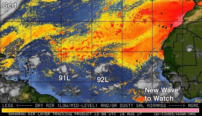
| Figure 2: The Saharan Air Layer (SAL) analysis from 8 am EDT Wednesday, August 16, 2017, showed that 91L was encountering dry Saharan air; 92L was in a moister environment. A new tropical wave to watch had just emerged from the coast of Africa. Image credit: University of Wisconsin CIMSS/NOAA Hurricane Research Division. |
91L struggling with dry air
A tropical wave located near 14°N, 47°W in the central tropical Atlantic at 8 am EDT Wednesday (Invest 91L) remains disorganized, but has the potential to develop into at least a tropical depression late this week as it moves westward at about 15 – 20 mph. Satellite images on Wednesday morning showed that 91L had only a limited amount of heavy thunderstorm activity, though the disturbance had acquired a bit more organization and spin since Tuesday. Wind shear was moderate, 10 – 15 knots, and sea surface temperatures were a warm 28°C (82°F)--about 0.5°C to 1°C above average for this time of year. The atmosphere surrounding 91L had dried since Tuesday, with relative humidity at mid-levels of the atmosphere as analyzed by the SHIPS model at 50%, down from 60% on Tuesday morning. This drier air was interfering with development.
Forecast for 91L
Conditions appear adequate for development through this weekend, though the atmosphere surrounding 91L will be dry (a mid-level relative humidity of 45 - 55%). Wind shear is predicted to be mostly moderate, 10 – 15 knots, through Sunday, and sea surface temperatures will be warm, 28 - 29°C (82 - 84°F).
The 0Z Wednesday runs of our top three models for predicting tropical cyclone genesis—the GFS, European, and UKMET models—all predicted 91L would develop into a tropical depression or weak tropical storm by Friday, when the storm will be moving through the Lesser Antilles Islands. Substantial support for development was also being provided by the ensemble forecasts from the GFS and European models, which had more than 50% of their 70 members predicting development. However, none of these forecasts had 91L developing into a hurricane, and 91L will likely meet less favorable conditions for development in the Eastern Caribbean. That region is climatologically unfavorable for tropical cyclone development, due to high surface pressures caused by a regime where the surface trade winds accelerate and cause widespread sinking air. In its tropical weather outlook issued at 8:00 am EDT Wednesday, the National Hurricane Center gave 91L 2-day and 5-day odds of development of 30% and 40%, respectively. The Hurricane Hunters are scheduled to investigate 91L on Thursday afternoon.
 |
| Figure 3. MODIS true-color satellite image of 92L on Wednesday morning, August 16, 2017. Image credit: NASA. |
92L looks a lot like 91L
A tropical wave (92L) was located about 700 miles east of 91L, near 14°N, 35°W, at 8 am EDT Wednesday. Satellite images on Wednesday morning showed that this eastern twin of 91L looked very similar, with a limited amount of heavy thunderstorm activity that showed a modest amount of spin and organization. Conditions were favorable for development, with light wind shear less than 10 knots, a moist atmosphere with a mid-level relative humidity of 65%, and warm SSTs of 27°C (81°F). The disturbance was headed west to west-northwest at 15 - 20 mph. More than 70% of the members of the 0Z Wednesday GFS and European model ensembles showed development of 92L into a tropical depression over the next five days, though the operational version of these models did not. The UKMET model predicted development early next week, though. The 12Z Wednesday run of the SHIPS model predicted that 92L would encounter high wind shear of 20 – 30 knots on Friday and Saturday, which would likely put the brakes on development. In its tropical weather outlook issued at 8:00 am EDT Wednesday, the National Hurricane Center gave 92L 2-day and 5-day odds of development of 30% and 40%, respectively. 91L and 92L are close enough together that they could affect each other’s track and intensity; in particular, if one develops significantly, its upper-level outflow could weaken the other.
Another strong tropical wave emerges from the coast of Africa
Yet another tropical wave with the potential to develop into a tropical depression emerged from the coast of Africa on Wednesday morning. The 0Z Wednesday operational runs of our three reliable models for predicting tropical cyclone genesis—the GFS, European and UKMET models—all predicted development of this new wave by early next week, as did more than 30% of the 70 members of the GFS and European model ensemble forecasts. (However, the 12Z run of the GFS model did not develop the system.) This wave--which will presumably be labeled 93L by NHC by Thursday--was predicted to take a more west-northwesterly track than 91L, and is less likely to pose a long-range threat to the Lesser Antilles Islands. In its tropical weather outlook issued at 8:00 am EDT Wednesday, the National Hurricane Center gave this future “Invest” 2-day and 5-day odds of development of 0% and 40%, respectively.
Bob Henson contributed to this post.


